Have you ever wondered who collects and manages the data on the wildlife and geology in your area? How can you access this information and contribute to it?
Biological records are vitally important as they underpin all conservation decision making and policy in the UK.
This data, collected by a diverse range of amateur and professional biological recorders, is collated, managed and shared by Local Environmental Records Centres.
What do Local Environmental Records Centres do?
Local Environmental Records Centres (LERCs) are not-for-profit organisations that collect, collate and manage information on the natural environment for a defined geographic area. The defined geographical area is usually a county, or several counties in some cases.
LERCs collect information on wildlife and geology for their area and supply it to a range of local users. They support biological recording, provide data products and services and support the community with their local knowledge and contacts.
LERCs also work with a network of organisations and individuals to ensure environmental information for their local area is reliable and robust. They then make this information accessible to a range of audiences, from decision-makers to the public and researchers. The data are used for a variety of applications on a local and national scale, such as to inform:
- Development proposals: records of species, habitats and sites feed into ecological surveys and impact assessments for developments like housing and new roads.
- Green infrastructure planning: records help to inform what kind of green infrastructure might be most suitable for a particular location, to maximise its value for biodiversity and people.
- Local Nature Recovery Strategies: these spatial strategies are currently being developed across the country by each local authority. They will be heavily informed by biological records to help create maps and evidence-based strategies for improving biodiversity in each local area, such as green corridors and habitat creation.
- Biodiversity Net Gain (BNG) calculations: BNG aims to leave biodiversity in a better state after development has taken place than it was in before it occurred. Biological records inform the calculations and proposals, such as what habitats should be created or enhanced.
- Research: biological records can be used for all kinds of research, such as studying change in distribution and abundance of species over time.
As well as sharing data, LERCs provide a whole range of services: from training and advice on habitat and species recording, to hosting public engagement events and conferences, providing grants for recording efforts, loaning survey equipment, and writing blogs, newsletters and other publications.
Where do LERCs get their records from?
The data that LERCs collate come from a range of sources such as expert volunteer recorders, professional ecologists, BioBlitzes and other recording events, as well as ad-hoc records made by members of the public.
With their local knowledge LERCs are able to spot gaps in their data. To make their data sets more comprehensive they will sometimes undertake field survey work themselves.
If you submit a biological record to an app like iRecord or iNaturalist, it will be made available to your LERC. Records that reach ‘research grade’ on iNaturalist are shared with iRecord first, and are then made available to LERCs in turn.
How are biological records checked and how do the LERCs know they are correct?
There are two processes that help to make sure biological records are correct, accurate and robust: validation and verification.
Validation
The validation process checks the completeness of the record.
The data managers will check the date format, species name and other fields in the record are correct and complete. For example, there is a lot of variation in the common names of species, and some common names refer to groups of species or more than one.
When submitting a record using a common (non-scientific) name, you therefore need to check that the name you are using is correct and associated with what you have seen: ideally you should check the most up to date scientific name too.
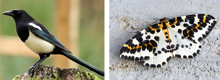
One example is ‘magpie’: without the Latin name and the context, you could either mean the bird Pica pica or the magpie moth Abraxas grossulariata.
The LERC will also check the georeference of the record: the grid reference or what3words location needs to be correct and accurate. Records submitted with a site name as well as a grid reference help when it comes to cross-referencing the location.
Most online recording platforms like iRecord, iNaturalist and online forms for national schemes like the Big Garden Birdwatch and Big Butterfly Count, only allow you to submit data in the correct format. This makes validation much simpler.
Verification
The verification process checks the accuracy of the identification of the things being recorded.
Artificial intelligence (AI) is increasingly being used to verify species that are easy to identify and/or are common. However, many species records need the skills and knowledge of national and local experts known as verifiers.
Verifiers are specialists in their field and volunteer to check the accuracy of species records for LERCs, national recording schemes and often platforms like iRecord. They use their knowledge of the species and its ecology with their knowledge of the locality where it was spotted to assess the likelihood of the record being correct.
They will then assign a verification level, for example: Correct, Considered Correct, Unable to Verify, Incorrect, or Plausable. To do this, they may ask you for evidence, such as a photograph, a specimen, or ask how you identified the species using ID guides. This is normal, so do not be offended if you are asked about your record!
If you think you have found something rare or a species that has not been recorded in your area before, it is best to take extra notes on the identification features and take close-up photographs from lots of different angles. This helps to give the verifier as much information as possible.
There are not always active verifiers for all species groups in all geographic areas. This may mean that your record is not verified, or may take a while to be. Don’t be disheartened if this is the case; keep submitting good quality records as most are still available to LERCs even if they are unverified.
How can I get involved with my LERC?
You can find your local LERC through the Association of Local Environmental Records Centres LERC-finder tool.
You can then visit your LERC’s website to see what kinds of services they provide, how you can find local wildlife recording groups and how you can share your wildlife sightings with them.


